Introduction
This page is not listed, by popular request. It's most likely this page was sent to you by invention. If this is not the case it was an accident you found it. Please keep this information to yourself to help preserve the special spots. (thanks)
Directions to riding areas
The chart, below, gives you a quick view for what you might be looking for. The areas with "features" such as climbing, trails, registration enforcement, Avalanche danger, and so on, with a rating of zero to four, zero being non-existing, and four being the highest in that category. For example, a "four" for enforcement, and a "zero" for "open fields" might indicate there are "cops" everywhere, (like Yellowstone) and no open fields. On the other hand, an avalanche danger of "four" with climbing of "four" indicates the best, wildest/best climbing, also with the highest danger of a slide. Some areas are shaded with some relevant subtle colors, just to catch a little attention, but not distract you, should you need to know about an outstanding feature of an area. The area(s) with very high avalanche danger is in bold red and please be careful. Please write if you have any information to add. A gray area(s) indicates no information is available at time of publishing.
For more information, such as driving directions, click on the area(s) you are interested in. This will open a new browser to view, and keep this page open as well. In these directions the Author will indicate personally being there to asses the features of that area. Otherwise, the information is second hand, with no guarantees of it's accuracy.
Down below there's some handy links and a map or two to show the general Pacific northwest area. This is based out of Spokane, Washington, where the Author is from, however, if you are coming in from another area, just follow the maps. From the Spokane and Coeur 'D Alene areas there are the four general directions to go.
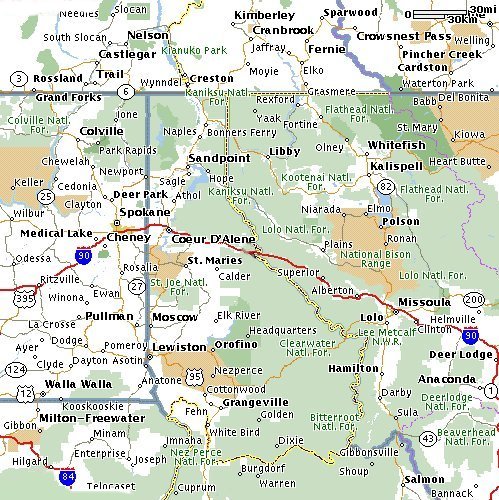
Here's a general map of the sled areas in of NorthEastern Washington and Northern Idaho for areas such as, Mt. Spokane, Priest Lake, Roman Nose, Lookout Pass, Burke, Lolo Pass, just to name a few. Most of the recognized (designated) areas and parks generally require either a state resident permit or an out of state permit. Some of the areas enforce them for trail riding; it's unknown about off trail stuff. Most of the permits are cheap; around 15 bucks. Most of the permits can be bought in the major towns, such Spokane, Coeur D Alene and Post Falls, Idaho. Another way to find out about them and trail maps is the local sled dealers.
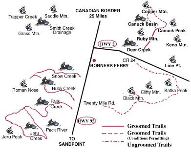
Here's a sled version map of the areas in NorthEastern Idaho, including Roman Nose.
| State | Area/ Mountain |
Climbing | Boon- docking |
Trees | Trails | Open fields |
Av/Cornice Danger |
Tabs Enforced | Large trailer friendly? |
Notes:
Areas are "rated" with numbers 1~4, and colored coded. The number indicates the amount, while the shade indicates the quality, or otherwise good-bad feature. A green shade is a good feature of this rating, while a red shade is a bad or dangerous feature of this rating. A question mark indicates this feature has not yet been verified so it's a guess at this time.
For example, Lookout Pass Avy rating of "3 ***", means most of the areas are medium risk, however the one area, St. Regis lake is a very high Av danger area, and there is a least one a major slide EVERY season. Therefore, it gets a high number, just because of that one (dangerous area) and red shade. Same goes for Priest Lake. Some of the areas with a "4" for trails (many, many trails) however, does not indicate the quality of them, nor how often they are groomed, so a high rating of trails with a red shade would indicate there are lots of poorly maintained trails. On the other hand, a low number of trails would indicate there's few of them, but with a green shade would indicate they are well maintained. For example, Revelstoke has some very good climbing areas, but the trail can be very bad and bumpy for many miles so it gets a red shade. Take this into consideration when planning a trip out of town for overnight. The "gray areas" are unknown-no information as of printing. If you have information, please email the Author.
Email, communications, radio, groups, etc.
One of the best ways to contact the group is on the 2-way radio. While cell phones work great, too, you might be out of range of a cell, while the 2-way radio works anywhere you are close to that other person you are trying to contact. Most riders use the Family Radio Service, or known as F.R.S.
F.R.S. radios are real handy whether in town or on the hill.
Here's a Frequency and tone (code) list if you need it.
Click here if you need to know about safety in the mountains.
Forums are a good way to coordinate trips. Such as Forums, like:
BCR Free Forum
RSS (rec.sports.snowmobiles)
Snow West Pay Forum (4M)
Arctic Chat Free Forum
Also, remember each State has some maps and directions, however may be out dated, due to lack of funds. While they are geared towards trail riding, some of the areas have access to off-trail riding, too.
Idaho has pretty good information about Mountain Passes, however, is almost impossible to find on the root of their web page. If they have not changed things this direct link should be working. (just click on their logo, here.
I'm usually looking for someone to ride with, so
email me
![[Kar's sled page]](images/winter_home3.gif)